
WI State Parks – Wyalusing State Park

Covid-19 caused a major change to my summer travel plans. I decided to stay closer to home in order to limit the number of people that I become exposed to. Rather than taking the 6 or 7 week trip to Alaska that I had planned, I decided instead to investigate the state parks in my home state of Wisconsin! Over the years, I have visited many of the state parks. With over forty different parks having campgrounds, there are still many that I have not seen. During the summer and fall, I plan to cross more of these parks off of my list!
I have spent time in almost every geological region of Wisconsin. Currently, I live in the Northern Highlands of Wisconsin. I was raised in the Glaciated Southeast. I’ve spent some time in the southwest, but have never followed the Wisconsin River to the place where it meets the mighty Mississippi River. This specific area of the state is called the Driftless Area.
The Driftless Area has many valleys and streams. During the Ice Age, when most of Wisconsin was covered by glaciers, this area was left exposed. No glacial debris, or glacial drift as it is called, was left behind when the glaciers melted. This gives the area the name “The Driftless Area.” It is completely different from the rest of the state.

My late husband John and I had done several canoe trips along the Wisconsin River between Sauk City and Lone Rock. It was our goal to complete the entire stretch of the Lower Wisconsin River by canoeing small portions each year. We would work on it bit by bit until we reached Wyalusing State Park, which is located at the end of the Wisconsin River. Wyalusing State Park is listed as one of the most popular parks in the state. This trip wouldn’t be the canoeing celebration I had always hoped for, but I was still looking forward to seeing what it had to offer!
Before Any RV Trip – Planning
Having traveled to this area before, I knew that there were no fast ways to get to Wyalusing State Park once I left the interstate. This was just fine with me as I enjoy taking scenic routes and I’ve had a love affair with the Wisconsin River, so bobbing along this 100 mile long scenic route would be a pleasure!
I checked the routes on Google Maps and planned to take highway 60 from Lodi, WI to Bridgeport where I would then cross the river and enter Wyalusing State Park. I had been on portions of this road before, but the segment from Gotham to Bridgeport would be new to me.
Lower Wisconsin River Road
This trip became as much about travelling along this road as it did about visiting the state park. The 100 mile stretch of highway 60, the Lower Wisconsin River Road, teases you. Initially, you travel a few miles before reaching the Wisconsin River, then you finally cross it only to travel alongside it with bluffs and hills and trees preventing you from seeing her again.
She hides from you, barely letting you catch a glimpse of her once in awhile for almost half of the trip. But you find yourself not caring because the hills and valleys and scenery of the area mesmerize you anyway.

Finally, at Gotham, highway 60 separates from highway 14 and dips even more deeply into the hills and valleys along the river. Each bend of the road brought Ooohs and Aaahhs until finally the river reveals herself in all of her glory. My family has always known that I consider the Wisconsin River to be “My River!” I’m sorry to the other taxpayers in the state, but she and I have shared a lifetime together. We are one and the same, this river and me.

She is nurturing, steady, and at times she can be mysterious. I like to think that I am these things as well. She is hard-working and gentle, but has moments of ferociousness. Those who I have gone toe to toe with will attest to my own ferociousness; my daughters have my ID on their phones listed as “Mamma Bear!”
I crossed the river five or six times on the interstate to get here. She begins her journey across the state just 30 minutes from where I live. I feel that we have been connected for all of my life. She is me and I am Her.
I felt at peace rambling alongside her, sharing the secrets of my soul with her and letting her carry them away to some distant place. Shortly after exiting the freeway I was back in the place of memories. I was back where I had spent so much time canoeing with my husband and I felt real sorrow. But within minutes of watching her waters cruise quietly and calmly along, she worked her magic and transformed me to feeling peace and joy. She always seems to have a way of connecting to my soul and healing me. She is MY river.
Wyalusing State Park

Wyalusing State Park is big. It is hilly, and there are places that a motorhome should not go! You wonder how I know this? Well, I know this because I foolishly decided to drive to some of these places in CeeCee! I immediately worried that I wouldn’t be able to turn around! I also worried about what would happen if I met anyone on one of those roads as we both would not have fit. Luckily, I managed to travel to some of these spots without meeting up with anyone else, and got out of the close quarters quickly!
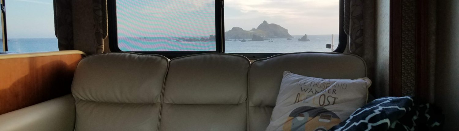
There are two family campgrounds in the park, Homestead Campground and Wisconsin Ridge Campground. Both have shower houses, and some sites in each campground have electricity. Some of the sites in the Wisconsin Ridge Campground are the most coveted in the state as they have unbroken views of both the Wisconsin River and the Mississippi River. These sites overlook the town of Prairie du Chein. Snagging one of those sites was pure luck! Although my site didn’t provide sweeping views, I still enjoyed amazing views that filled the entire back window of CeeCee.

The Wisconsin Ridge Campground is close to a playground, basketball court and tennis court. There is also a ball field. A concession stand sells treats, ice, firewood, souvenirs and has canoe and kayak rentals. A second playground area is located near the Homestead Campground. The parks are rather large.
In order to get to the picnic areas, different campgrounds, and the boat landing you will need a car or be willing to bike up and down some serious hills! (Or daringly take your big rig up there and hope you get as lucky as I did that no one else was coming!) There is no swimming area at this state park, so my focus was on hiking. I decided to do two hikes, Sand Cave Trail and Bluff Trail. These plans, and the lack of swimming, were not popular with my daughters!
We arrived late in the afternoon, and the campground was pretty full for a weekday. This wasn’t a surprise because the reservation calendar on the website showed that the park was booked solid. CeeCee groaned up the large hills and meandered the narrow road until she found site 137. It was on a steep little hill with four trees lining the driveway. I would have to back into it from the narrow camp road, down the hill, carefully making the sharp turn on my blind side. I hoped to do this maneuver while avoiding all of the trees! Luckily, the couple camping in the site across the road had left space which allowed me to pull into their site, helping CeeCee to slip into the narrow opening. After a few attempts and repositioning, she was in!
The forecast for the next few days showed that it would be very hot and humid, with temperatures rising quickly once the sun came up. By the time we were ready for the first hike, it was already pretty hot.
Sand Cave Trail
I loaded up my backpack with water and my typical hiking supplies, grabbed my trekking poles, and we walked the one mile to the trail head. Sand Cave Trail is categorized as an easy 2.5 mile semi-loop trail with a waterfall. Recently, it had been rainy in the area. People who posted comments about the trail on All Trails talked about portions being under water and very slippery. The ground here is a clay based soil that holds the water on top, taking a long time to dry.
We started on the trail, happily walking along the edge of a ravine. We felt cooled by being in the woods. I have a lot of issues with balance. Because of this I needed to spend a lot of time watching where to step because the clay trail was pretty wet. I could see marks from the slips of previous hikers. We went along for a long time and reached a point where the trail connected with a spur. It was confusing where we should go, and I needed to refer to my downloaded phone map to make the decision. I’m used to seeing signs posted along the trail that say, “You are Here,” but this trail didn’t have any.
After hiking an even more slippery trail, the temperatures rose more and more and we became discouraged. It seemed like we should have reached the waterfall long ago. Convinced that we had taken a wrong turn, I dreaded the hike back as everything to this point had been mostly downhill. The return trip would be up, up , up!

Suddenly, just when we had given up all hope, we heard the waterfall. Once we arrived at Little Sand Cave, we stood for awhile and just enjoyed the cooler air coming from the fresh spring water. Then we began our uphill journey back to the starting point.
Here is another moment of honesty. I am an unfit, older hiker with really poor balance. In my opinion, this trail is not accurately labeled! This trail can be quite a little workout! Maybe I would have felt differently if the trail had been dry and it had been a cooler day, but the uphill portions were unforgiving for me. The spur trail takes you another mile to Big Sand Cave, which ultimately I had hoped to go to, but changed my mind because of the conditions that day. We returned to CeeCee after finding a geocache near the trail head, and I felt like I had accomplished a great feat in that 3.5 mile hike!

Bluff Trail
The forecast for the next day showed even higher temperatures and more humidity. I had planned to hike the entire 1 mile Bluff Trail, where the end of the trail would bring me to another cave and several outlooks over the rivers. Neither of the girls wanted to hike, so I decided to go by myself and get an early start before the temperatures really started climbing.
I only walked a very small portion of this trail. In fact, if I’m being completely honest, the part I hiked really wasn’t part of the trail at all! It was a short segment that falls between the Bluff Trail and the Sentinel Trail. And also, if I’m being honest, I was glad to have this small hike after the day before because I knew that this hike would again include hills, I was in the Driftless Area after all!

I walked to the concession stand and down the path to the first overlook, Council Point. The path was paved for a portion, but the surface was still uneven and I was glad to have my trekking poles. When the paving disappeared, the ground returned to the damp clay that I had hiked on the day before, but today it was less slippery.
The path follows the Wisconsin River, where you can catch glimpses of the river down below. I arrived at Signal Point after a very short hike. A train crossed the trestle into Prairie du Chein and I spotted a kayaker out on the flooded river. It was nice to have this quiet morning time to myself. Another short hike took me to the steps to Treasure Cave. This is where the Bluff Trail officially begins (or ends). I wished that it were cooler so that I could complete the loop, but I knew that this was not the day to do it.

After Treasure Cave I continued on to Point Lookout where I found a picnic table and bench to sit down at while taking in the view. And that is exactly what I did! I sat and just enjoyed the view, chatting with a couple that had also come out early to get their hike completed before the temperatures became unbearably hot.
Another moment of honesty is needed here! This hike really wasn’t even a hike, it was more of a short walk! After this gorgeous walk and the views from my campsite and the sites along the ridge, I realized why Wyalusing State Park is so special! I know that I will make plans to return. Heck, I want to drive along highway 60 again, too!

Final Thoughts
This is a big park with lots to offer! The campsites along the ridge in the Wisconsin Ridge Campground are worth hunting for! Some of the sites across the road have electricity and also get a great view, but not as amazing as those right on the ridge. The next time I come, I want a campsite on the ridge again! I will happily encourage CeeCee into a site that offers those views!
Pros and Cons of Wyalusing State Park
Pros: The views! That is what this park is all about! Gorgeous views from the top of the bluff overlooking two major rivers. I have never seen campsites in Wisconsin with views as amazing as this! There are lots of different trails, including mountain bike trails! The playground areas were a nice surprise. If it hadn’t been so hot I’m sure that we would have spent considerable time at the volleyball net.
Cons: A common problem for me is not the park itself, but more of a problem for those who go camping with a Class A, Class B, or Class C motorhome. If you do not tow a vehicle with you, the campground is only accessible by bike or by foot. Wyalusing is a big park with lots of hills, so those with motorhomes need to be aware of what they need easy access to. The campsites along the ridge in Wisconsin Ridge Campground are very close to one another. The sites are exposed to neighbors. The trees have been cut back so that everyone can enjoy the view. Even though you can see several sites from your own (and hear every conversation) the people in the sites are more interested in the views of the river than they are in watching you camp!
Want to read about adventures in other Wisconsin State Parks? Check out the post about my trip to Amnicon Falls State Park and Pattison State Parks!
If you would like to go RVing, Here’s Everything You Need To Know!
